Wintertime, no snow except up on the mountains, so it's time to explore the Desert. Roy and I decided to go out to Anza Borrego and check out the Calcite Mine area. Since Roy is still recovering from his sore wrist (from tripping over a dog), we are in exploring mode these days. That works fine for me, I love exploring and I'm not that familiar with Anza Borrego. Roy has been putting his time to good use and researching old Desert Magazines for tips on interesting places to explore, he also has been spending some time with a friend who lives near the park. On this January trip, we are between storms, one has recently been through and another is on the way.

As we enter the Palm Wash, the effects of the recent rain are quite apparent with all the mud. Fortunately the rains were mild and we have firm ground for the most part.

One thing that we notice about the rain, is that the wet conditions really bring out the colors. Normal dry conditions give a lot of pastel colors, but when wet they really stand out. The different colors are a result of flooding by the Colorado River a very long time ago, Roy says before he can remember.

Our first stop is the natural bridge. This is a column of sandstone that eroded away at the base until it fell over and caused this natural bridge. It's different than what you would normally expect in the desert southwest, but it's what we have here in the local desert.

After visiting the bridge, we get back on the road to the Calcite mines and start noticing the scenery. This part of the wash appears to be about 400 feet deep. About this time we are very impressed with the canyons and wish the road was a little wider.

Soon we are at the mine area and start taking in the views. Here Roy is taking in the vistas, with the Salton Sea in the distance and Red Top off to the right.

Soon we are looking at the mines. The calcite was formed in cracks in the ground and the method of mining was to dig out the dikes of calcite that were formed. This resulted in a landscape covered with trenches. Here we are looking into on the of the trenches, this is one of the more vertical ones we saw.

While exploring we kept taking time to appreciate the magnificent scenery, this is looking out at the badlands and the road we drove in on.

Here is another trench, notice that there were no machines digging here, the walls have the unmistakable scars from pick work. Not an easy way to make a living.

After checking out the mine site we noticed a trail heading up the mountain to the north and decided to follow it.

As I was walking along the ridge, I noticed a crack in the ground. I thought to myself that I wouldn't want to step in the crack, might break a leg, but then another thought came to mind. If I'm walking along a ridge, where does this crack go? As I started looking more carefully, I realized that it was part of erosion and that one side of the ridge was beginning to separate from the rest and would be falling down the side of the steep slope. I quickly made sure I was on the side that would be staying for a bit longer.

Looking down at Roy coming up the trail, you can see the split in the ridge. The right side is breaking away from the rest of the ridge and will cause a significant rock slide when it goes. Yes, it is easily big enough to step in.

We were fortunate that the Ocotillo were in bloom, giving us some bright color in the desert. As we continued up the ridge, with some sections very steep and some fairly level, it soon became clear that we had underestimated the size of the mountain and decided to turn back.

Going down it was more noticeable how narrow the ridge was in places. This is not much more than a use trail and as you can see, the slopes drop off right away. With the steepness of the slopes, this was a very scenic hike.

Once back down we decided to do some exploring in the badlands area. Here we are looking back up at the mountains, we turned around on the flat section in the middle of the skyline. At first we thought the ridge was rugged, coming into this area we had to redefine the term.

As we started this second hike of the day, Roy had asked me if I thought we would be able make the trip before the rain came, we could see it off in the distance. I thought it appeared to be moving slowly and told him that it would be fine, we'd be back in plenty of time. If you know me, you know that I normally don't do rain. Once we had hike out into the canyons and whetted our appetites for hiking in the area, Roy told me that we should turn around soon, since he figured that the rain was about 10 miles away and heading in our direction. With that he turned around and started heading back to the car.

I couldn't quite bring myself to turn around quite so soon, I had too much to look at, including this canyon. I quickly changed my mind when I realized that Roy's 10 mile estimate was a bit off, it should have been 1/10 of a mile. I was in high gear (for me) getting back to the car before I got too wet.

All too soon the sky completely opened up, but not before I made it back to the car. As we were driving out we noticed some young men hiking in, wearing blue jeans and hooded sweatshirts. I guess they really wanted to make the hike to continue in such a heavy rain, no doubt they were totally soaked in a few minutes. We didn't let it dampen our spirits, we knew we had just scratched the surface of what the are has to offer and were already making plans to return.
 As we enter the Palm Wash, the effects of the recent rain are quite apparent with all the mud. Fortunately the rains were mild and we have firm ground for the most part.
 One thing that we notice about the rain, is that the wet conditions really bring out the colors. Normal dry conditions give a lot of pastel colors, but when wet they really stand out. The different colors are a result of flooding by the Colorado River a very long time ago, Roy says before he can remember.
 Our first stop is the natural bridge. This is a column of sandstone that eroded away at the base until it fell over and caused this natural bridge. It's different than what you would normally expect in the desert southwest, but it's what we have here in the local desert.
 After visiting the bridge, we get back on the road to the Calcite mines and start noticing the scenery. This part of the wash appears to be about 400 feet deep. About this time we are very impressed with the canyons and wish the road was a little wider.
 Soon we are at the mine area and start taking in the views. Here Roy is taking in the vistas, with the Salton Sea in the distance and Red Top off to the right.
 Soon we are looking at the mines. The calcite was formed in cracks in the ground and the method of mining was to dig out the dikes of calcite that were formed. This resulted in a landscape covered with trenches. Here we are looking into on the of the trenches, this is one of the more vertical ones we saw.
 While exploring we kept taking time to appreciate the magnificent scenery, this is looking out at the badlands and the road we drove in on.
 Here is another trench, notice that there were no machines digging here, the walls have the unmistakable scars from pick work. Not an easy way to make a living.
 After checking out the mine site we noticed a trail heading up the mountain to the north and decided to follow it.
 As I was walking along the ridge, I noticed a crack in the ground. I thought to myself that I wouldn't want to step in the crack, might break a leg, but then another thought came to mind. If I'm walking along a ridge, where does this crack go? As I started looking more carefully, I realized that it was part of erosion and that one side of the ridge was beginning to separate from the rest and would be falling down the side of the steep slope. I quickly made sure I was on the side that would be staying for a bit longer.
 Looking down at Roy coming up the trail, you can see the split in the ridge. The right side is breaking away from the rest of the ridge and will cause a significant rock slide when it goes. Yes, it is easily big enough to step in.
 We were fortunate that the Ocotillo were in bloom, giving us some bright color in the desert. As we continued up the ridge, with some sections very steep and some fairly level, it soon became clear that we had underestimated the size of the mountain and decided to turn back.
 Going down it was more noticeable how narrow the ridge was in places. This is not much more than a use trail and as you can see, the slopes drop off right away. With the steepness of the slopes, this was a very scenic hike.
 Once back down we decided to do some exploring in the badlands area. Here we are looking back up at the mountains, we turned around on the flat section in the middle of the skyline. At first we thought the ridge was rugged, coming into this area we had to redefine the term.
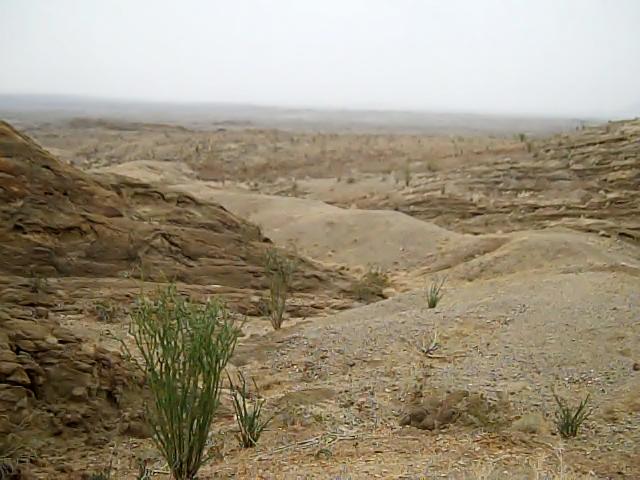 As we started this second hike of the day, Roy had asked me if I thought we would be able make the trip before the rain came, we could see it off in the distance. I thought it appeared to be moving slowly and told him that it would be fine, we'd be back in plenty of time. If you know me, you know that I normally don't do rain. Once we had hike out into the canyons and whetted our appetites for hiking in the area, Roy told me that we should turn around soon, since he figured that the rain was about 10 miles away and heading in our direction. With that he turned around and started heading back to the car.
 I couldn't quite bring myself to turn around quite so soon, I had too much to look at, including this canyon. I quickly changed my mind when I realized that Roy's 10 mile estimate was a bit off, it should have been 1/10 of a mile. I was in high gear (for me) getting back to the car before I got too wet.
 All too soon the sky completely opened up, but not before I made it back to the car. As we were driving out we noticed some young men hiking in, wearing blue jeans and hooded sweatshirts. I guess they really wanted to make the hike to continue in such a heavy rain, no doubt they were totally soaked in a few minutes. We didn't let it dampen our spirits, we knew we had just scratched the surface of what the are has to offer and were already making plans to return.
No comments:
Post a Comment