Showing posts with label Desert. Show all posts

Sunday, July 11, 2010

Picacho Peak Again

This is a continuation from the Indian Pass post, this is day two of the adventure. We last saw our fearless trio exploring along the Colorado River and finally coming into view of Pichacho Del Diablo late in the afternoon. We normally camp in a small wash north of the peak, but on our last visit we found that with washouts the going was much more difficult on the vehicle, 4x4 wasn't enough, higher clearance was needed. In order to maintain our reputation as being efficient climbers, that means saving your energy for when you really need it, we tried to find a closer spot to camp. We think we most likely succeeded, but we aren't too sure, the effort in driving to our campsite involved about as much work as hiking the extra distance in the standard wash. We had an unremarkable evening and then went to sleep. Roy slept by the car and Charlene and I went down into the wash to sleep on the sand. I always think sand is more comfortable to sleep on than rocks and gravel.

During the night we found out that we weren't the only ones who like being down in the wash, as a group of burros came through. We were woken up and they were surprised, they didn't know what to do so they stomped around us for a while and then finally went on their way, allowing us to go back to sleep.

As the sun came up, we had our traditional egg breakfast and then started hiking to the peak. For quite a ways we followed the tracks of a Rhino or similar vehicle, I was surprised at how rugged the terrain was that they were able to navigate. Those vehicles must be very capable, or the driver really into pushing it, or both. The hike in seemed to be about 15 minutes shorter than on our last trip, so I guess we were really closer. Soon we reached the base and started climbing up the slopes to the base of the cliffs.

Charlene being a good sport, but the smile shows some uncertianty

As always, the hike up to the cliffs is a grind on those of us who need to get in better shape. You would think that I know I need more exercise and wouldn't go out on these confirmations trips so often.

Youth wins again, Charlene at the base of the cliff

We made our way over to the gully leading to the start of the climbing. Roy had gotten a little behind but soon caught up with us and we started the 3rd class up the gully.

Looking up the 3rd class gully

As we moved up the gully, we took advantage of the views for excuses to stop and catch our breath.

Soon we were on the climb, Charlene on the first ladder

Roy coming up the first ladder

After the first ladder the route works it's way back and forth, always going higher on the north face of the peak. During this time one is always amazed that this route exists. It looks impossible that a relative easy climb could be made when looking from below, but improbable ledges cut into the side of the cliff keep making diagonals ever up towards the top. Soon we were at the second ladder. This one is much more exposed (much better view) than the first.
One of the features that help make it interesting is the fact that it's a very narrow ladder and it wobbles also. Thank goodness for the very tired looking old piece of webbing tied to the top.

Roy coming up the second ladder

As you stand up on the shoulder of the rock, you notice a tremendous view and that you are now on top levels of the rock.

View as you stand on shoulder above second ladder

From this point you walk over a low rise to the middle of the top. Here is a vertical section that blocks your way. For this short section, you have to do a couple of 5th class moves.

Here I am, getting ready to make the 5th class moves up the rock


In the middle of the moves
Finishing the moves

And standing up on the top

After getting up on the block, I quickly secured the rope to some bolted anchors and brought everyone else up. After we were all on top, we then walked about 70 feet to the other end of this block and had to rappel down the other side in order to continue up to the actual summit.

Roy rappelling down the other end of the block

Charlene making the rappel

After the rappel we left the rope in place, since we won't need it again until we head back down the peak and have to climb back onto the block in the middle of the top. From there it's just a few hundred feet of walking along the top, with a gradual elevation gain to the true summit.

Charlene and Roy walking over to the summit

The summit register

Charlene getting me in trouble with her mother, by telling her where we are

After signing the summit register, eating a snack and making important phone calls, we headed back down.

Charlene watches as I get ready to ascend the rope to the top of the block

I'm climbing the rope to the top of the block

It normally takes just a few minutes to ascend the rope, although there have been notable exceptions. We then walked back across to the other end and rappelled back down that end.

Charlene on the final rappel

After the rappel it's then a simple matter of retracing your steps back to the bottom, with the ladders and step across to slow you a little.

Improbable trails along the side of the cliff

Charlene and Roy hiking down the diagonals

Roy on the incredible terrain

A natural bridge

Please stay on the trail

Roy on the famous "step across"

Charlene on the "step across"

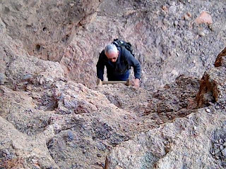
Most of us don't have the nerve to come down the ladder like this

Charlene has a much more confident look as we near the bottom of the climb

The view out the opposite side of the approach gully

Once we were off the climb, we changed out of our rock shoes and headed back down the approach gully. Soon we were at the base. We decided to try a different trail and make a shortcut.

Hey, let's follow this trail, it looks like a shortcut

Well, that doesn't make such a good descent route after all, next time stay on the regular trail

This is an impressive formation that we hiked past on the way back to the car, the "finger" is about 100 feet tall.

Once back at the car, we treated ourselves to a well deserved lunch and then continued with our explorations.

Indian Pass Indian Trail


February came and it was time to get out again. Roy informed me that after our stellar performance in Joshua Tree, we needed to do some desert exploring. I agreed, since I had a good compromise in mind. With the information that Roy had been "feeding" me regarding the area around Picacho Peak, I thought that we needed to make another visit and see some of the other points of interest in the area.

Charlene, my youngest daughter, joined us so we had another set of hands to help out with the cameras and chores. We started out our trip going more east, through the town of Glamis, than we normally do. I hadn't been this way before and had a whole new appreciation for the sand dunes that are named after Glamis. On the east side of the dunes we made our first stop, at a Pre Columbian Indian Trail. The trail consisted of a section of trail along side of the highway, with a fence along the edges of the trail for few hundred feet. It didn't seem all that impressive, but over the next several hours it would become much more so.

Marker along highway, The sign says:

PRE-COLUMBIAN INDIAN TRAIL
COLORADO RIVER TO LAKE COACHWILLA
(NOW IMPERIAL VALLEY)
ERECTED BY
IMPERIAL VALLEY PIONEERS ASSN.
1965

I've never heard of Lake Coachwilla before, so I'm guessing they're referring to ancient Lake Cahuilla. The obvious age of the trail was the most arresting aspect of the site, along with a section just past the fenced area where the trail went what is a small wash, which has a spot where it appears that water would collect after rains and would have been an important stopping point on the journey.

Location where trail crosses dry stream bed, shaded spot in middle is where water collects.

We then continued the drive to an area known as Indian Pass. I had read about this area in articles in the old Desert Magazine and when searching the area on Google Maps, had seen what I thought were trails visible in the satellite photos of the area. Sure enough, the trail was easy to spot and follow. We ended up hiking much farther than I expected, a couple of miles, until we lost the trail in the sandy washes.

Here we are returning from the wash where we lost the trail. From all appearances, most people don't walk anywhere near this far from the road.

Where the trail goes through the rocks with the heavy patina or desert varnish, the trail is visible on satellite maps.

We saw several mortars along the trail

Following the trail with the pass in the background

Where the trail entered the area of white rock, it wasn't visible on satellite photos, but was still easy to follow.

Charlene checking out some mortars or grinding holes

In the upper middle part of this photo, you can make out a faint circle where the larger rocks have been removed. Many think these circles may have been campsites.

More grinding holes

The peculiar scratches on the rocks in this area, have not been found anywhere else

The trail through the heavy patina covered rocks

More of the mysterious scratches


Of course, graffiti is found in modern flavors as well. This are modern petroglyphs. After seeing the "modern art", we continued east through the pass toward the Colorado River.

Soon we found ourselves at Picacho State Recreation Area. Here Roy is paying the day use fee.

We then went down to the water and had a little picnic. The river is pretty here and we recognize these cliffs from our climbs of Picacho Peak.

Looking up river from our picnic spot

As we drove along the river we checked out some of the side canyons. Roy is looking at the cliffs, making sure that we don't need to climb them.

Charlene is looking at the pools of water from the rains about a week earlier

We are stopped from going any further by this waterfall

Some of the roads we check out are not designed for the family sedan. Note the dirt being sprayed by the driver's side front tire.

While driving along the river we came across this memorial to a dog called Lonesome. It's located on a small hill with a nice view of the river. I wonder how long before erosion will take away this little hill?

We stopped at a boat-in campground. While it's designed for boaters, you can walk in to it also.

One of our last stops of the day was the state park campground and visitor center. Of course you wouldn't want to be a visitor here in the old miner's cemetery. We took a little hike and checked out some of the sights, including the marina and then as the sun was getting lower in the west, we headed out for our last stop of the day.

After a very interesting day we finally set up camp, under the cliffs of Picacho Peak.